
Record setting heat is expected over the next several days from the Intermountain West through the northern Plains. Furthermore, fire weather concerns increase with dry and breezy conditions. Meanwhile, heavy rainfall and severe thunderstorm threats for the Ohio/Tennessee Valleys, central Appalachians and Southeast today. The threat shifts to central Gulf Coast and across central Texas this week. Read More >
Overview
|
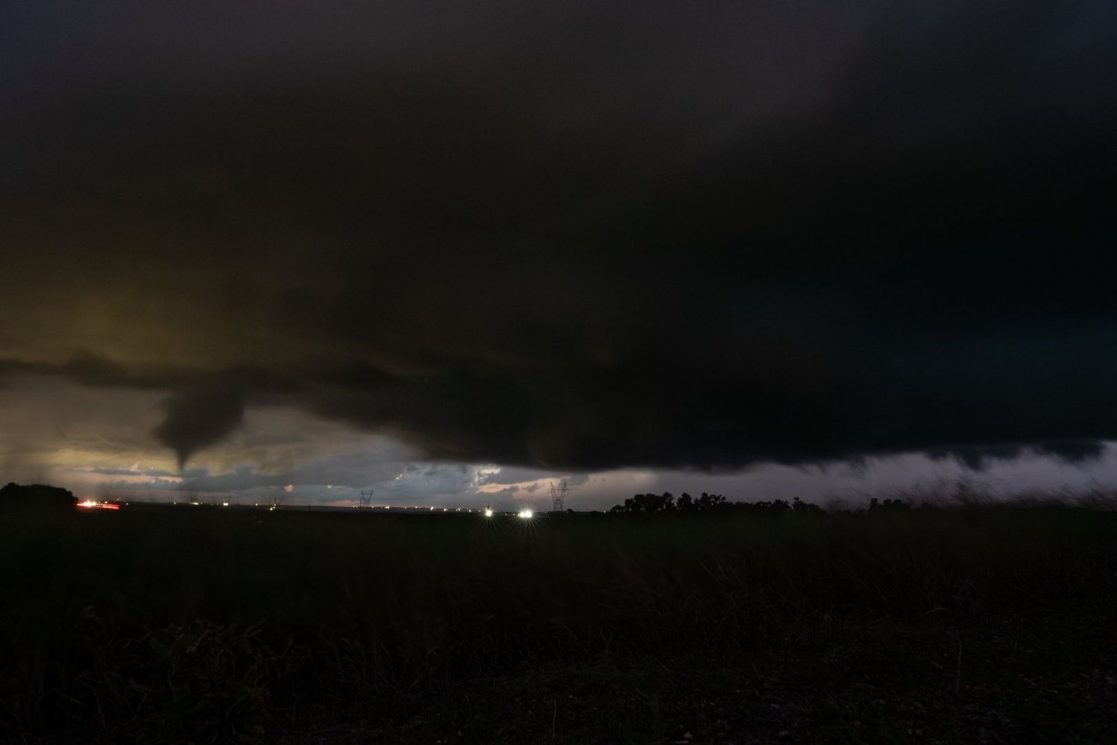
On the evening of Friday, June 27, 2025, several supercell thunderstorms spawned numerous tornadoes and produced very large hail across central North Dakota. The first tornado touched down in Oliver County around 7:40 PM CDT. Less than an hour later, another tornado was spotted north of Crown Butte Lake in northeast Morton County. Then after nearly an hour and a half, 7 tornadoes were reported in the span of an hour, from around 10:15 to 11:15 PM CDT in Burleigh, Kidder, and Emmons Counties. The strongest tornado, which was rated an EF-2, caused damage to a farmstead west of Temvik in Emmons County. 2 of the other tornadoes touched down just to the north of the city limits of Bismarck, but only caused limited damage. There are 9 confirmed tornadoes from this event. In addition to the tornadoes, these storms produced very large hail, including 3.5 inch diameter hail from the same storm that produced the first tornado in Oliver County. While all the tornadoes and the largest hail reported were in south central North Dakota, severe thunderstorms impacted north central parts of the state as well. Several reports of golf ball to baseball size hail were received from McLean and McHenry Counties. Note...the information on this site is considered preliminary unless otherwise noted. This site may be updated as more information becomes available. |
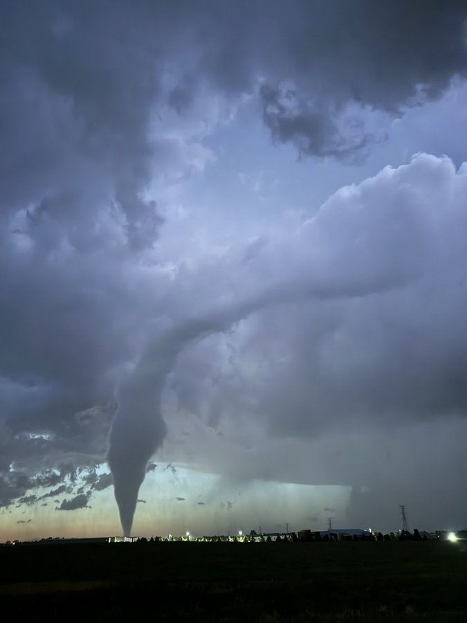 Tornado north of Bismarck. Photo Courtesy of Nick Smego |
 |
 |
 |
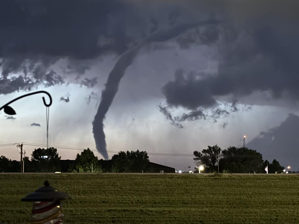
| Tornado North of Bismarck. Photo Courtesy of Holly Winn | Tornado North of New Salem. Photo Courtesy of Justin Turcotte | Tornado near Sterling. Photo Courtesy of Michael LaBeau |
Tornadoes
Select a tornado from the table to zoom into the track and view more information. The default table view is limited to 8 tracks, but can be scrolled by a mouse wheel or dynamically expanded. Additionally, the table can fill the entire window by clicking the small circular expanding arrow icon at the very top right of the table and returned to its original size by clicking the button again. The side information panel that opens over the map can be closed using the "X" on the upper right corner of the pop-up. Zoom into the map and click damage points to see detailed information and pictures from the surveys.
|
NOTE: times shown below are local to your device's time zone. |

The Enhanced Fujita (EF) Scale classifies tornadoes into the following categories:
| EF0 Weak 65-85 mph |
EF1 Moderate 86-110 mph |
EF2 Significant 111-135 mph |
EF3 Severe 136-165 mph |
EF4 Extreme 166-200 mph |
EF5 Catastrophic 200+ mph |
 |
|||||
| Tornadoes that fail to impact any ratable damage indicators on the EF-Scale are rated EF-Unknown (EF-U) | |||||
Photos & Video
Tornado Photos
 |
 |
 |
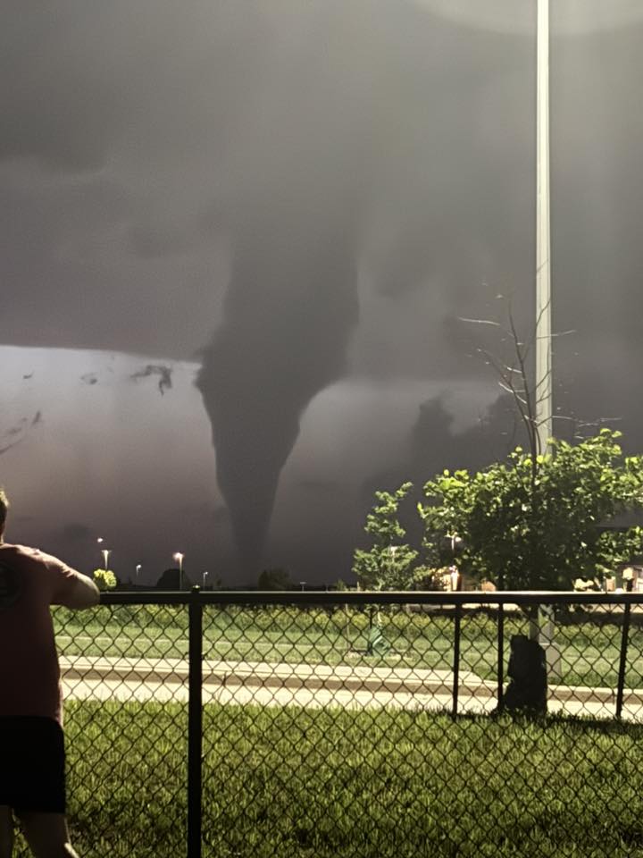 |
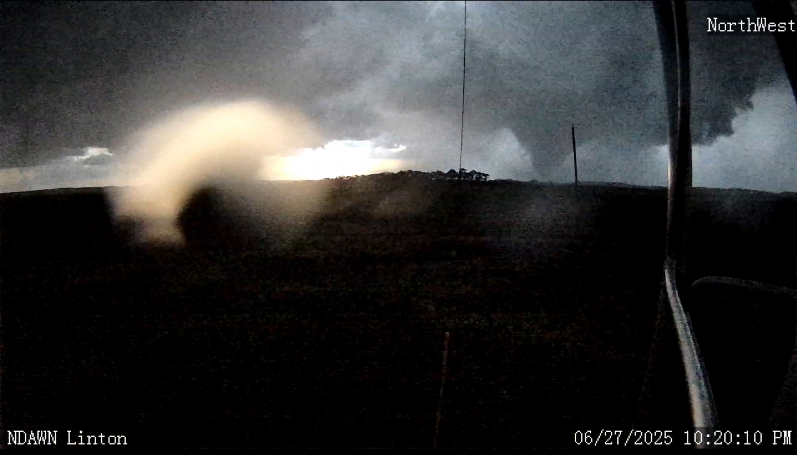
| Tornado near Linton (NDAWN) |
Tornado near Menoken (Shane Ornelas) |
Tornado near Center (Stephanie Clarys) |
Tornado near Bismarck (Krystal Atkinson) |
Survey Damage Near Bismarck
 |
 |
 |
| Farm building damage near Bismarck (NWS Storm Survey Photo) |
Damage to a camper (NWS Storm Survey Photo) |
Tree damage (NWS Storm Survey Photo) |
Public Information Statement
National Weather Service Bismarck ND
225 PM CDT Sun Jun 29 2025 /125 PM MDT Sun Jun 29 2025/

...NWS Damage Survey for 06/27/2025 Tornado Event...

Video evidence gathered from social media verifies that a supercell
thunderstorm produced two tornadoes just north of Bismarck, North
Dakota, on the evening of Friday, June 27th 2025. The first
tornado resulted in damage at a residence along 110th Ave NW. The
tornado tracked south, across the roadway and dissipated in an
open field. The tornado lasted approximately 4 minutes. A second
tornado then developed south of 110th Ave NW and drifted slowly
southwest before dissipating in the same open field. The second
tornado lasted approximately 5 minutes.

.Bismarck Tornado 1...

Rating:                 EF1
Estimated Peak Wind:    95 mph
Path Length /statute/:  0.33 miles
Path Width /maximum/:   Unknown
Fatalities:             0
Injuries:               0

Start Date:             06/27/2025
Start Time:             10:23 PM CDT
Start Location:         8 N Bismarck / Burleigh County / ND
Start Lat/Lon:          46.928 / -100.7913

End Date:               06/27/2025
End Time:               10:26 PM CDT
End Location:           8 N Bismarck / Burleigh County / ND
End Lat/Lon:            46.9238 / -100.7882

Survey Summary:
Video and numerous photos from social media indicated a tornado
formed approximately 8 miles north of Bismarck. A storm survey
found that the tornado developed just north of a residence on
110th Ave NW, an east to west roadway. The tornado moved from north
to south across the residence lot, causing significant roof damage
to an outbuilding, toppling a covered trailer and snapping or
uprooting a few trees. The tornado crossed 110th Ave NW and
snapped several branches of a large cottonwood tree in the ditch
on the south side of the roadway. The tornado then traveled a few
hundred feet into an open field before dissipating. The damage
found was consistent with EF1 tornado damage with estimated peak
winds of 95 mph.

.Bismarck Tornado 2...

Rating:                 EFU
Estimated Peak Wind:    Unknown
Path Length /statute/:  0.46 miles
Path Width /maximum/:   Unknown
Fatalities:             0
Injuries:               0

Start Date:             06/27/2025
Start Time:             10:29 PM CDT
Start Location:         7 N Bismarck/ Burleigh County / ND
Start Lat/Lon:          46.9154 /-100.7906

End Date:               06/27/2025
End Time:               10:34 PM CDT
End Location:           7 N Bismarck / Burleigh County / ND
End Lat/Lon:            46.9118 / -100.7989

Survey Summary:
Numerous photos and video evidence from social media showed
that a tornado developed over open country approximately 7
miles north of Bismarck at 10:29 PM CDT. The tornado drifted
slowly to the southwest, and then dissipated at 10:34 PM CDT.
A damage survey turned up no damage caused by this tornado.
Due to the fact that this tornado developed and remained over
open country, with no damage found, the tornado was given a
rating of EFU, meaning a tornado of unknown intensity.

&&

EF Scale: The Enhanced Fujita Scale classifies tornadoes into the
following categories:

EF0.....65 to 85 mph
EF1.....86 to 110 mph
EF2.....111 to 135 mph
EF3.....136 to 165 mph
EF4.....166 to 200 mph
EF5.....>200 mph

NOTE:
The information in this statement is preliminary and subject to
change pending final review of the events and publication in
NWS Storm Data.
Survey Damage Near Hannover
|
|
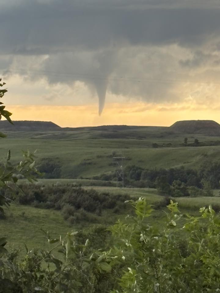
| Tornado north of New Salem (Justin Turcotte) |
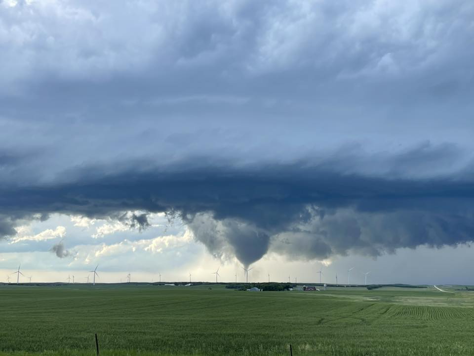
Tornado near Center (Stephanie Clarys) |
Public Information Statement
National Weather Service Bismarck ND
303 PM CDT Mon Jun 30 2025 /203 PM MDT Mon Jun 30 2025/

...NWS Damage Survey for 6/27/2025 Tornado Event...

.Hannover Tornado...

Rating:                 EFU
Estimated Peak Wind:    Unknown
Path Length /statute/:  3.46 miles
Path Width /maximum/:   Unknown
Fatalities:             0
Injuries:               0

Start Date:             06/27/2025
Start Time:             07:45 PM CDT
Start Location:         5 SW Hannover / Oliver County / ND
Start Lat/Lon:          47.0422 / -101.4936

End Date:               06/27/2025
End Time:               07:53 PM CDT
End Location:           6 S Hannover / Oliver County / ND
End Lat/Lon:            47.0196 / -101.4307

Survey Summary:
Numerous photos and videos showed a tornado forming in an open
field southwest of Hannover at approximately 7:45 PM. The tornado
slowly tracked 3.5 miles to the southeast over the next 8 minutes
or so before dissipating south of Hannover near Highway 31. There
is no known damage from this tornado, therefore the rating is EF-
Unknown.

&&

EF Scale: The Enhanced Fujita Scale classifies tornadoes into the
following categories:

EF0.....65 to 85 mph
EF1.....86 to 110 mph
EF2.....111 to 135 mph
EF3.....136 to 165 mph
EF4.....166 to 200 mph
EF5.....>200 mph

NOTE:
The information in this statement is preliminary and subject to
change pending final review of the event and publication in
NWS Storm Data.
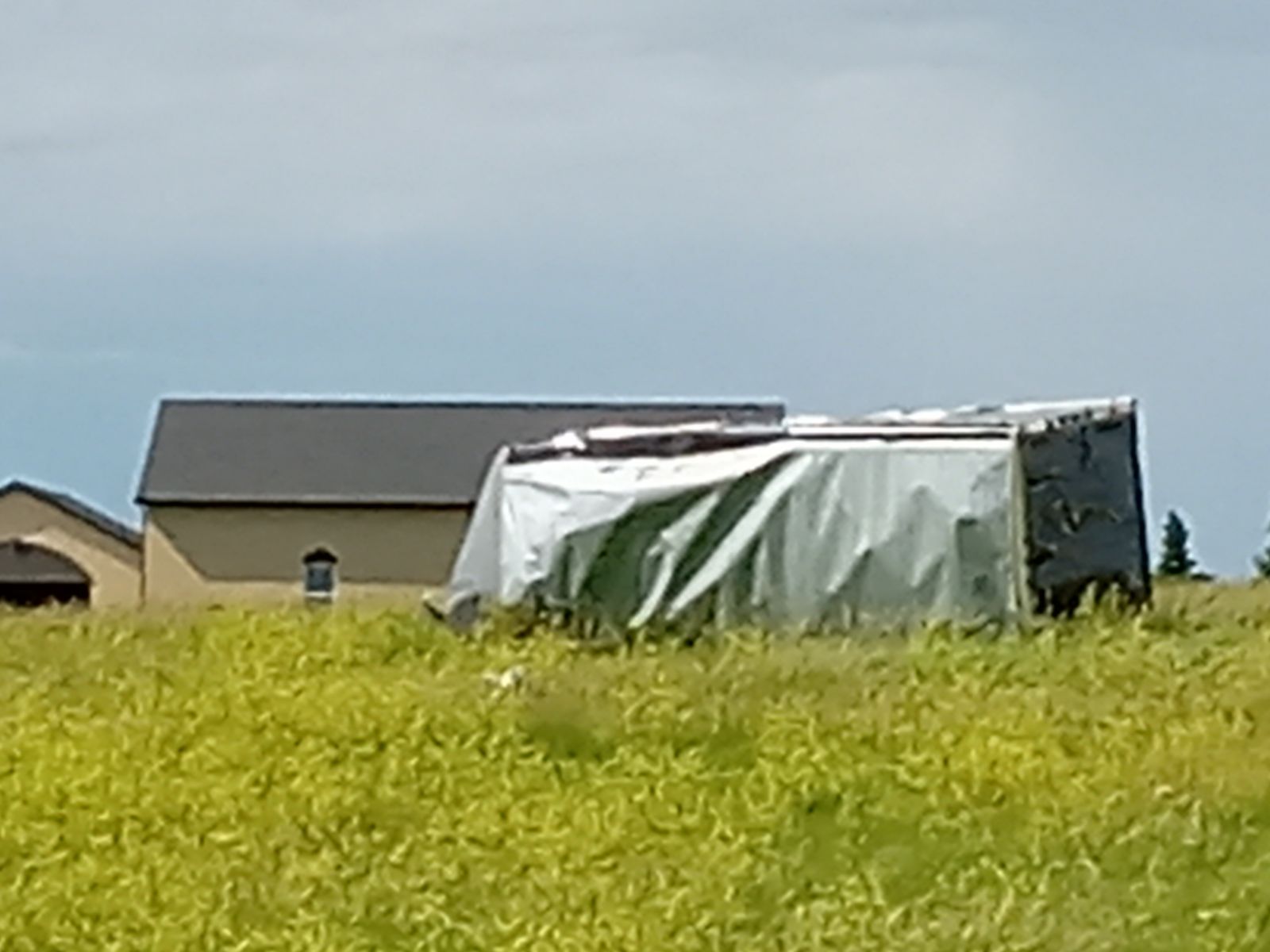
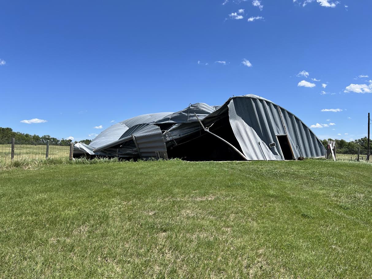
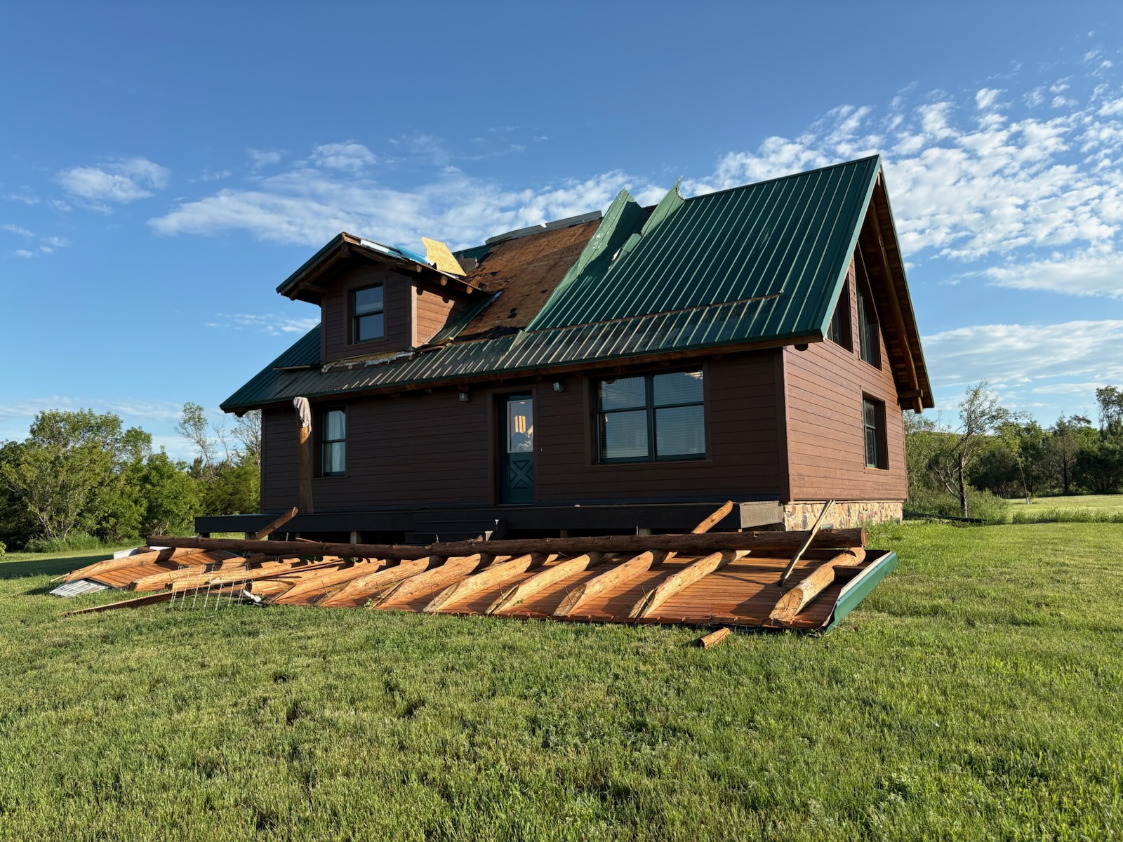
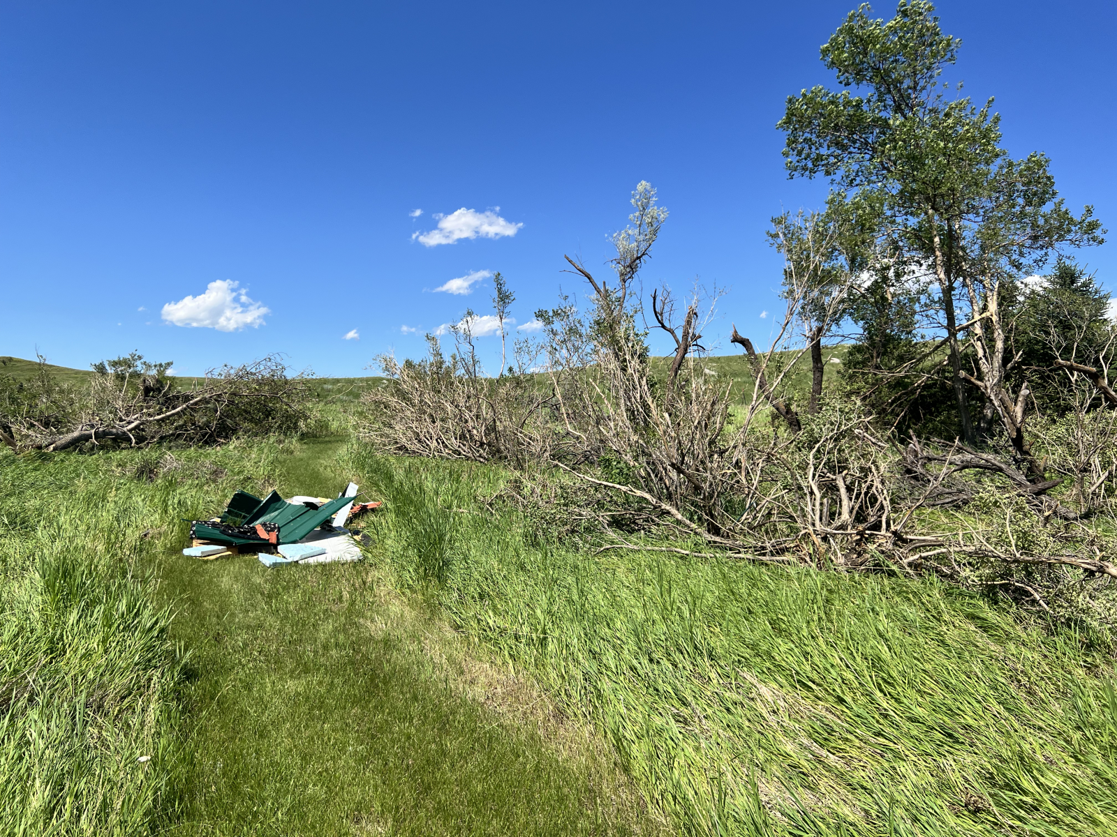
Survey Damage Near Temvik
 |
 |
 |
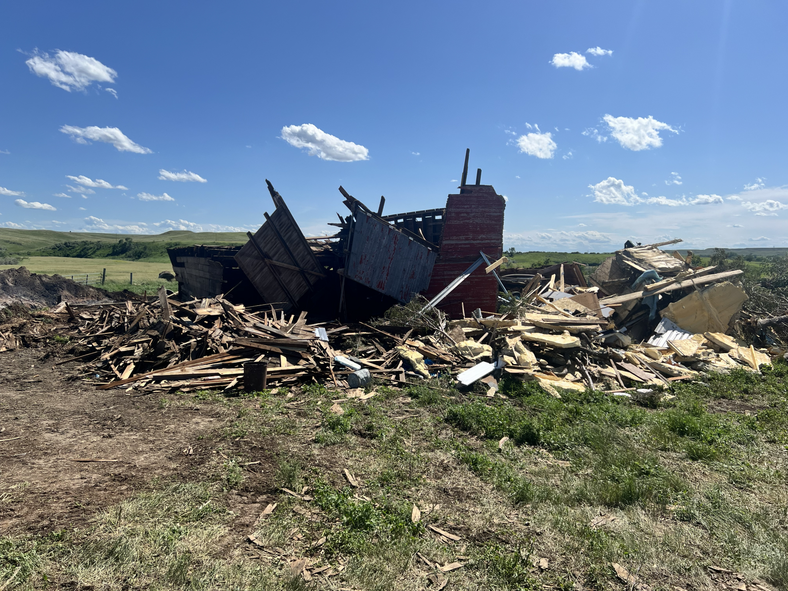 |
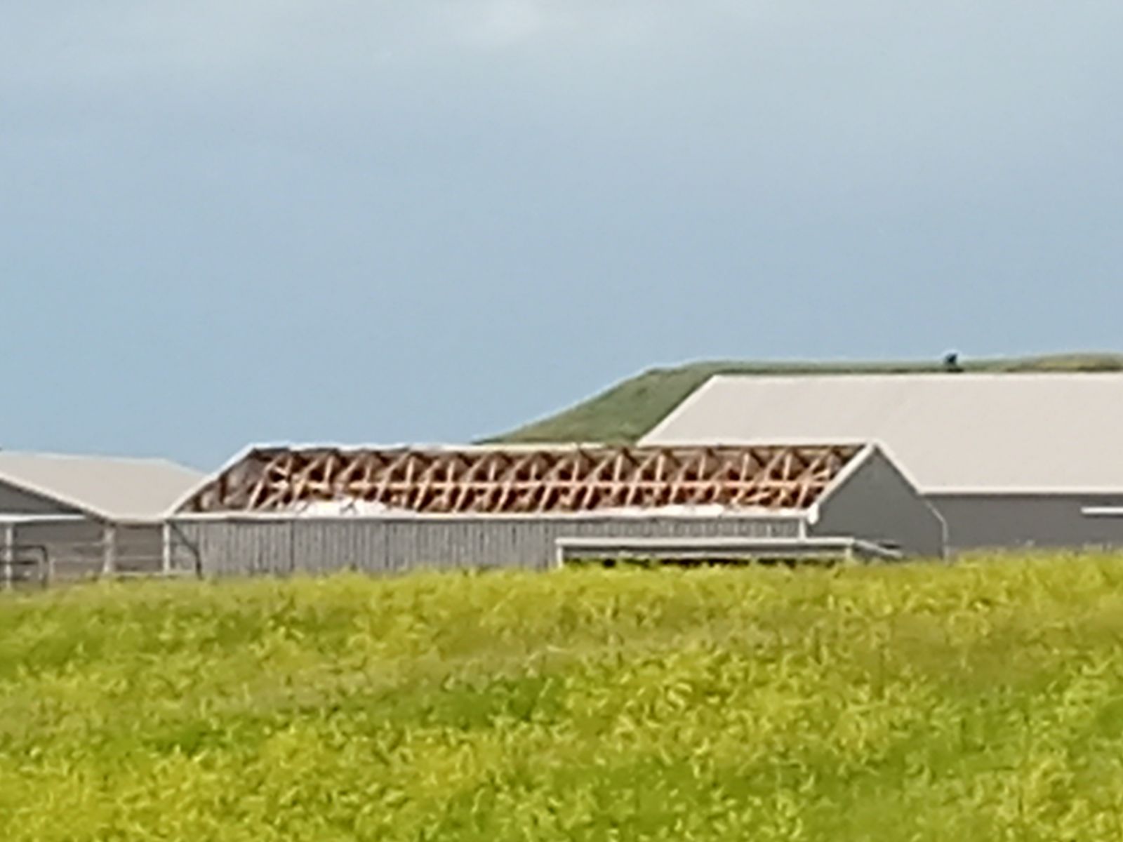
| Farm building damage near Temvik (NWS Storm Survey Photo) |
House damage near Temvik (NWS Storm Survey Photo) |
Tree damage near Temvik (NWS Storm Survey Photo) |
Farm building damage near Temvik (NWS Storm Survey Photo) |
Public Information Statement
National Weather Service Bismarck ND
817 PM CDT Mon Jun 30 2025 /717 PM MDT Mon Jun 30 2025/

...NWS Damage Survey for 06/27/2025 Tornado Event...

On the evening of June 27th, 2025, a supercell thunderstorm
produced two tornadoes west of Temvik, North Dakota in Emmons
County. According to eyewitnesses and video evidence, the first
tornado touched down in an open field about 4 miles WSW of Temvik,
just to the west of 4th Ave SE at around 10:12 PM CDT. The
tornado crossed the road to the east and impacted a residence
consistent with EF1 damage and lifted after moving off to the
northeast. The first tornado was on the ground for a little bit
over a minute.

About five minutes later, a second tornado developed just to the
south of another property around 3 miles W of Temvik. Damage was
surveyed at the impacted residence, consistent with EF2 damage.
The tornado continued to move off to the north and crossed 72nd
St. SW before traveling another mile and dissipating over an open
field around 10:30 PM CDT.

.Temvik Tornado 1...

Rating:                 EF1
Estimated Peak Wind:    108 mph
Path Length /statute/:  0.22 miles
Path Width /maximum/:   0 yards
Fatalities:             0
Injuries:               0

Start Date:             06/27/2025
Start Time:             10:12 PM CDT
Start Location:         4 WSW Temvik / Emmons County / ND
Start Lat/Lon:          46.3422 / -100.3391

End Date:               06/27/2025
End Time:               10:13 PM CDT
End Location:           4 WSW Temvik / Emmons County / ND
End Lat/Lon:            46.3435 / -100.3352

Survey Summary:
According to video and eyewitnesses, the first tornado formed at
10:12 PM CDT in an open field just to the west of 4th Ave SE. The
tornado then crossed the road to the east and knocked over a power
pole before impacting a residence. Some roof covering damage,
siding, and window/door damage was surveyed and the owner reported
a slight shift of the foundation. The tornado also destroyed a
few outbuildings anchored with chains and produced significant
damage to a large Quonset. The tornado threw a large stainless
steel trailer around 250 yards east into a field and threw another
smaller trailer around 350 yards east, landing in a grove of
trees. Damage was consistent with EF1 damage with peak winds up to
108 mph. The tornado continued to move northeast, snapping some
hardwood trees in a shelterbelt before lifting at a little after
10:13 PM CDT.

.Temvik Tornado 2...

Rating:                 EF2
Estimated Peak Wind:    120 mph
Path Length /statute/:  1.82 miles
Path Width /maximum/:   0 yards
Fatalities:             0
Injuries:               0

Start Date:             06/27/2025
Start Time:             10:18 PM CDT
Start Location:         3 W Temvik / Emmons County / ND
Start Lat/Lon:          46.3604 / -100.3254

End Date:               06/27/2025
End Time:               10:30 PM CDT
End Location:           3 WNW Temvik / Emmons County / ND
End Lat/Lon:            46.3859 / -100.3285

Survey Summary:
According to video evidence which lines up with radar data, a
second tornado developed at 10:18 PM CDT just south of a residence
around 3 miles west of Temvik. The tornado picked up a large
horse trailer and threw it around 150 yards north northeast into a
tree. The tornado then destroyed a new large metal workshop,
small garage, and a large wooden barn. The workshop and garage had
both been anchored into concrete slabs. This damage was
consistent with EF2 tornado damage with estimated peak winds of
120 mph. The tornado also produced EF1 damage to the main
residence just to the west. Significant roof covering damage was
surveyed and a well built porch was blown off of the house.
Widespread tree damage was noted to several hard and softwood
trees around the property. The tornado then continued to move
north along the general path of the driveway, snapping more
hardwood trees to the east before crossing 72nd St SW. There were
two more hardwood trees with large branches broken off just to the
north of 72nd St SW. According to satellite and radar data, the
tornado continued to track north northwest for around another mile
before dissipating over an open field at approximately 10:30 PM
CDT.

&&

EF Scale: The Enhanced Fujita Scale classifies tornadoes into the
following categories:

EF0.....65 to 85 mph
EF1.....86 to 110 mph
EF2.....111 to 135 mph
EF3.....136 to 165 mph
EF4.....166 to 200 mph
EF5.....>200 mph

NOTE:
The information in this statement is preliminary and subject to
change pending final review of the events and publication in
NWS Storm Data.
Storm Reports
..TIME... ...EVENT... ...CITY LOCATION... ...LAT.LON...
..DATE... ....MAG.... ..COUNTY LOCATION..ST.. ...SOURCE....
..REMARKS..
1045 PM Hail Bowdon 47.47N 99.71W
06/27/2025 E1.75 Inch Wells ND Public
Relayed through broadcast media. Time
estimated from radar.
1230 AM Tstm Wnd Gst 3 ESE Jamestown 46.89N 98.65W
06/28/2025 M65 MPH Stutsman ND Mesonet
NDDOT sensor.
0720 PM Hail 6 S Hazen 47.21N 101.62W
06/27/2025 E1.25 Inch Oliver ND Public
Photo relayed via social media.
0725 PM Hail 10 W Hannover 47.12N 101.65W
06/27/2025 M1.75 Inch Oliver ND Trained Spotter
0727 PM Hail 10 WNW Hannover 47.15N 101.62W
06/27/2025 E3.00 Inch Oliver ND Public
Relayed through social media. Largest
hailstone was 3 inches in diameter. Also
noted tree limbs down, a broken window, and
lots of denting to shop and barn.
0731 PM Hail 6 WNW Hannover 47.16N 101.54W
06/27/2025 E2.50 Inch Oliver ND Trained Spotter
Hail lasted until 7:38 PM. Largest was the
size of tennis balls.
0734 PM Hail 7 W Hannover 47.11N 101.58W
06/27/2025 E2.50 Inch Oliver ND Public
Relayed via broadcast media.
0735 PM Hail 3 NW Hannover 47.14N 101.47W
06/27/2025 E3.00 Inch Oliver ND Public
Photo from Skyspy photos of hail
approximately 3 inches in diameter.
0741 PM Tornado 6 SW Hannover 47.05N 101.51W
06/27/2025 Oliver ND Trained Spotter
Trained spotter and multiple public reports
of a tornado at 7:41 PM. Tornado lasted
approximately 9 minutes before ending.
Photos of the tornado were sent via social
media.
0756 PM Hail 2 S Hannover 47.08N 101.43W
06/27/2025 E3.50 Inch Oliver ND Public
Relayed through social media. Time estimated
from radar.
0829 PM Tornado 8 NNE Crown Butte Lake 46.98N 101.04W
06/27/2025 Morton ND Trained Spotter
Trained spotter reported elephant trunk with
faint intermittent brief ground circulations
from their view. Lasted until 8:38 PM.
0842 PM Hail 8 NE Crown Butte Lake 46.95N 100.99W
06/27/2025 E2.75 Inch Morton ND Public
Hail up to the size of baseballs was falling
at the time of the report. Only a few
hailstones, but some were as large as
baseballs.
0849 PM Hail 8 NE Crown Butte Lake 46.95N 100.97W
06/27/2025 E1.75 Inch Morton ND Public
Report from mPING: Golf Ball (1.75 in.).
0853 PM Hail 9 N Mandan 46.95N 100.92W
06/27/2025 E2.50 Inch Morton ND Public
Report relayed via broadcast media.
0719 PM Hail 6 S Douglas 47.77N 101.52W
06/27/2025 E2.50 Inch McLean ND Trained Spotter
Hail, mostly golf ball sized but some to
tennis ball sized, began at 7:19 PM and
lasted until 7:34 PM.
0805 PM Hail 6 SW Benedict 47.76N 101.18W
06/27/2025 M2.00 Inch McLean ND Cocorahs
Cocorahs daily report notes included mention
of hail up to 2 inches. Station Max 6.4 SE.
Time estimated from radar.
0821 PM Hail 5 S Max 47.76N 101.29W
06/27/2025 E1.75 Inch McLean ND Public
Report from mPING: Golf Ball (1.75 in.).
0825 PM Hail 8 S Benedict 47.72N 101.08W
06/27/2025 M2.40 Inch McLean ND Trained Spotter
Report from ICECHIP research project. Time
estimated from radar and hail measured a few
minutes after it fell.
0826 PM Hail 5 SSW Strawberry Lake 47.69N 100.91W
06/27/2025 E1.86 Inch McLean ND Public
Report from ICECHIP research project.
Largest 47 mm, most 20 to 35 mm. Noted from
left mover.
0915 PM Hail 5 SW Strawberry Lake 47.69N 100.91W
06/27/2025 E1.75 Inch McLean ND Public
Report from mPING: Golf Ball (1.75 in.).
Time estimated from radar.
0730 PM Hail 4 NW George Lake 48.14N 100.45W
06/27/2025 E1.50 Inch McHenry ND Public
Report from mPING: Ping Pong Ball (1.50
in.).
0732 PM Hail 3 NNW George Lake 48.14N 100.41W
06/27/2025 E1.00 Inch McHenry ND Public
Relayed from social media.
0743 PM Hail 5 NW George Lake 48.15N 100.45W
06/27/2025 E1.50 Inch McHenry ND Public
Report from mPING: Ping Pong Ball (1.50
in.).
0745 PM Hail 3 WSW George Lake 48.09N 100.45W
06/27/2025 E2.75 Inch McHenry ND Broadcast Media
A few baseball size hail, most golf ball
sized. Relayed via broadcast media.
0752 PM Hail 7 N Towner 48.44N 100.41W
06/27/2025 E1.25 Inch McHenry ND Public
Time estimated by radar. Relayed via social
media.
0807 PM Hail Karlsruhe 48.09N 100.63W
06/27/2025 E1.50 Inch McHenry ND Public
Report from mPING: Ping Pong Ball (1.50
in.).
0815 PM Hail Karlsruhe 48.09N 100.62W
06/27/2025 M1.25 Inch McHenry ND Trained Spotter
Hail quarter to half dollar size was falling
at the time of the report. Winds of 40 to 50
mph preceded the hail.
0815 PM Hail 2 S Karlsruhe 48.06N 100.63W
06/27/2025 M1.69 Inch McHenry ND Trained Spotter
Report from ICECHIP research project.
0832 PM Hail 6 SSW Orrin 48.02N 100.24W
06/27/2025 M1.00 Inch McHenry ND Trained Spotter
Quarter sized hail ongoing at time of call.
0853 PM Hail 6 SSW Orrin 48.02N 100.24W
06/27/2025 E2.50 Inch McHenry ND Trained Spotter
0130 AM Rain 7 N Verona 46.47N 98.07W
06/28/2025 M2.02 Inch LaMoure ND Public
Still raining.
0745 AM Rain 7 N Verona 46.47N 98.07W
06/28/2025 M2.44 Inch LaMoure ND Public
1106 PM Tornado 8 SE Driscoll 46.75N 100.03W
06/27/2025 Kidder ND Storm Chaser
1106 PM Tornado 9 SSE Driscoll 46.72N 100.06W
06/27/2025 Kidder ND Storm Chaser
0143 PM Tornado 7 E Bordulac 47.39N 98.82W
06/28/2025 Foster ND Public
Multiple reports of two landspout tornadoes
ongoing at time of report.
0320 PM Hail 3 W Mchenry 47.58N 98.66W
06/28/2025 M1.25 Inch Foster ND Trained Spotter
This is a delayed report from Saturday June
28th. Hail began at 3:20 PM and lasted 10
minutes. When the hail began it was the size
of quarters, but in the 10 period, the max
size was half dollar size.
1006 PM Funnel Cloud 5 WSW Temvik 46.34N 100.34W
06/27/2025 Emmons ND Fire Dept/Rescue
Location estimated from radar.
1014 PM Tornado 4 WSW Temvik 46.35N 100.33W
06/27/2025 Emmons ND Fire Dept/Rescue
Tornado has been intermittently touching the
ground and lifting. Was on the ground at the
time of report.
1019 PM Tornado 2 W Temvik 46.37N 100.30W
06/27/2025 Emmons ND Mesonet
Second confirmed tornado from storm north of
Linton. NDAWN Linton video shows initial
rope tornado (first LSR sent from southwest
Temvik) that quickly lifted, before second
tornado formed and was larger and
longer-lived. Time from NDAWN video.
1146 PM Hail 1 NW Temvik 46.38N 100.27W
06/27/2025 E1.25 Inch Emmons ND Public
Time estimated from radar.
0849 PM Hail 4 N Mandan 46.89N 100.89W
06/27/2025 E1.25 Inch Burleigh ND Public
Mixed with nickel sized hail. Relayed as
photo via social media.
0916 PM Hail 7 NE Bismarck 46.88N 100.69W
06/27/2025 E1.75 Inch Burleigh ND Public
Relayed through social media. Time estimated
from radar.
1015 PM Hail 2 W Baldwin 47.03N 100.79W
06/27/2025 M1.00 Inch Burleigh ND Public
Report from mPING: Quarter (1.00 in.).
1019 PM Hail 4 SW Baldwin 46.98N 100.79W
06/27/2025 E2.25 Inch Burleigh ND Public
Report from mPING: Hen Egg+ (2.25 in.). Time
estimated from radar.
1020 PM Hail Baldwin 47.03N 100.75W
06/27/2025 E2.50 Inch Burleigh ND Public
Photo relayed via social media.
1022 PM Hail 5 S Baldwin 46.95N 100.76W
06/27/2025 M2.25 Inch Burleigh ND Public
Relayed through social media. Hail the size
of a billiard ball. Time estimated from
radar.
1022 PM Hail 4 SSW Baldwin 46.98N 100.79W
06/27/2025 M2.26 Inch Burleigh ND Trained Spotter
Report from ICECHIP research project.
1025 PM Tornado 6 SSW Baldwin 46.94N 100.79W
06/27/2025 Burleigh ND Trained Spotter
1029 PM Tornado 7 N Bismarck 46.91N 100.80W
06/27/2025 Burleigh ND Trained Spotter
Second of two tornadoes north of Bismarck.
Video footage of tornado on ground starting
at 10:29 PM with dissipation at 10:34 PM.
Tornado appeared to be slowly drifting
towards the southwest.
1043 PM Tornado 3 WNW Menoken 46.84N 100.59W
06/27/2025 Burleigh ND Trained Spotter
1100 PM Tstm Wnd Dmg 2 W Mckenzie 46.82N 100.45W
06/27/2025 Burleigh ND Trained Spotter
Delayed report of two large trees uprooted
and laying on road. Time estimated by radar.
1112 PM Tornado 2 W Menoken 46.82N 100.58W
06/27/2025 Burleigh ND Law Enforcement
Law Enforcement relayed report of tornado on
the ground.
1112 PM Tornado 6 SSW Mckenzie 46.75N 100.45W
06/27/2025 Burleigh ND Law Enforcement
&&
$$
Radar
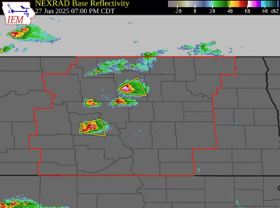 |
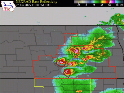 |
| Radar loop from 7 PM CDT to 1105 PM CDT on June 27th | Radar loop from 11 PM CDT June 27th to 215 AM CDT June 28th |
Environment
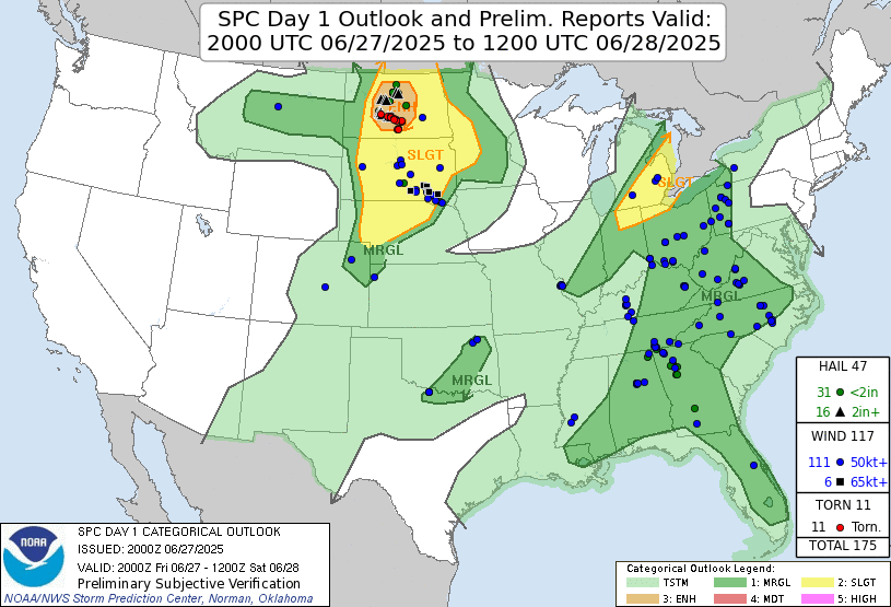
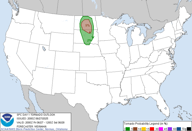
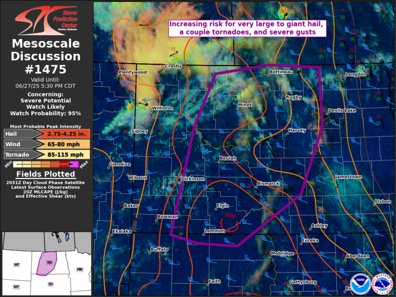
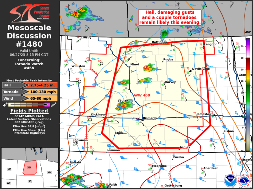
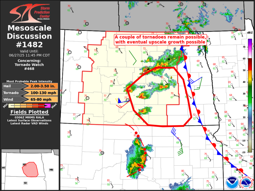
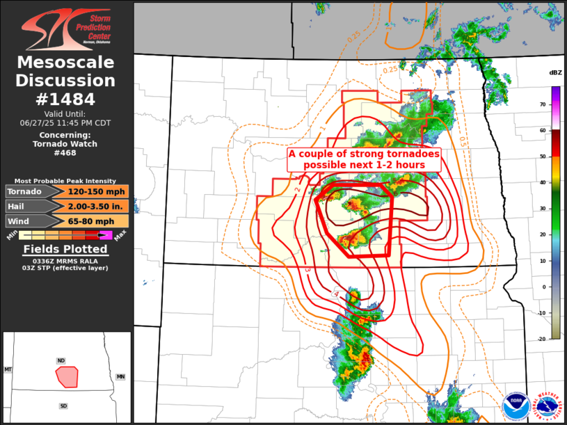
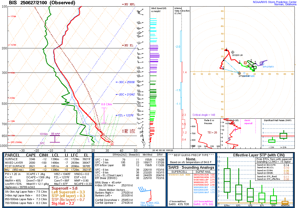
A fast moving shortwave trough aloft, combined with ample moisture from southerly flow at the surface, provided an active evening of severe weather across central North Dakota on June 27th 2025. The Storm Prediction Center (SPC) had a broad area of Slight Risk (level 2 out of 5) across central and eastern North Dakota. In the late afternoon update SPC upgraded to an enhanced risk (level 3 out of 5) in central North Dakota for an increased hail and tornado threat. With high amounts of surface based CAPE, and effective bulk shear with the vector perpendicular to the mentioned wave, SPC issued a Mesoscale Discussion for increased concerns for very large hail and a couple of tornadoes possible. A special sounding launched by NWS Bismarck confirmed these concerns, although initially showed a limited tornado potential. The synoptic sounding at 00z from NWS Bismarck showed increasing low level shear and storm relative helicity, thus indicating an increase to the tornado threat. This threat only increased through the evening as Significant Tornado Parameters increased (not shown). The first reported tornado near Hannover, ND occurred around 741 PM, with tornado reports continuing through the late evening. A Tornado Watch was issued for this event from about 520 PM CDT until 1 AM CDT for much of central North Dakota.
 |
 |
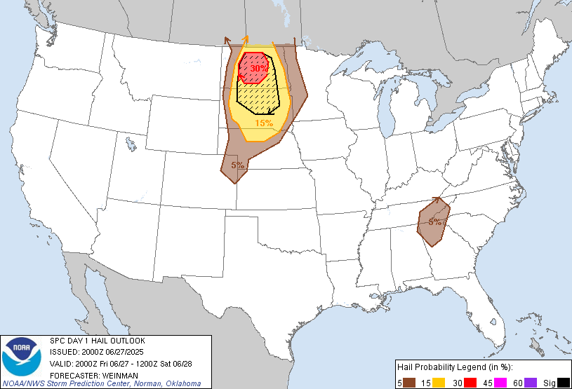 |
| Figure 1: SPC afternoon convective outlook with storm reports overlaid | Figure 2: SPC tornado outlook during the afternoon update | Figure 3: SPC hail outlook during the afternoon update |
 |
 |
 |
| Figure 4: SPC Mesoscale Discussion issued at 3:38 PM CDT, highlighting the environment becoming more favorable for severe thunderstorms. | Figure 5: SPC Mesoscale Discussion issued at 7:19 PM CDT, after storms had begun to develop, discussing likely hazards through the evening. | Figure 6: SPC Mesoscale Discussion issued at 10:10 PM CDT, in the middle of the event, highlighting a couple of tornadoes still possible across parts of south central and southeast North Dakota. |
 |
 |
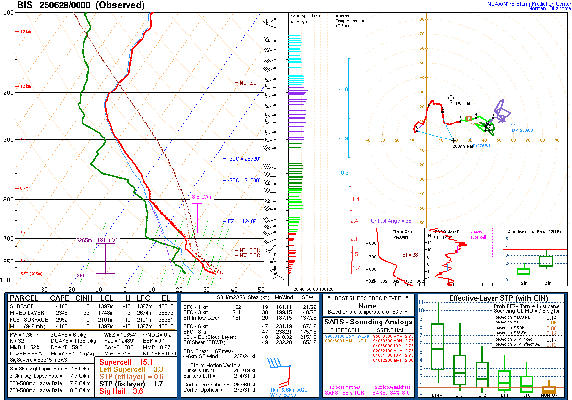 |
| Figure 7: SPC Mesoscale Discussion issued at 10:40 PM for an even smaller area of south central North Dakota. This discussion focused on ongoing supercells and the potential for a couple of strong tornadoes in the hour or two following this discussion issuance. | Figure 8: Observed upper air sounding from Bismarck, taken at 3 PM CDT. | Figure 9: Observed upper air sounding from Bismarck, taken at 6 PM CDT. |
 |
Media use of NWS Web News Stories is encouraged! Please acknowledge the NWS as the source of any news information accessed from this site. |
|

