Latest aviation discussion:
.AVIATION /06Z SUNDAY THROUGH THURSDAY/...
Conditions will be VFR to start. There are some early morning
showers showing up on radar. Conditions are dry near the surface
so it may take some time for the rain to actually reach the
ground. Scattered showers and isolated thunderstorms are
possible today and tonight. Ceilings will gradually decrease
from west to east throughout the daytime hours, falling as low
as IFR to LIFR at most terminals. Visibilities will also be
reduced slightly with passing showers. There will likely be dry
periods this afternoon and early evening between showers.

South to southeasterly winds will pick up today with speeds near
or exceeding 10 kts and peak gusts of 20 to 25 kts. Winds become
calmer tonight though gusts up to 15 kts will still be possible,
especially at BGM, ELM, and ITH.

Outlook:

Monday...Rain showers and restrictions likely, with a chance
for thunderstorms.

Tuesday...Mainly VFR; low chance for showers and restrictions at
AVP.

Wednesday through Thursday...Showers likely and isolated
thunder; associated restrictions possible.
|
This discussion and more can be found in the Area Forecast Discussion.
Aviation Forecasts
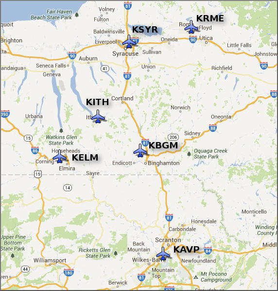
The National Weather Service Office in Binghamton, NY has responsibility for six Terminal Aerodrome Forecasts or TAFs in Central New York and Northeast Pennsylvania.
Click on a site on the map below to view the latest TAF.
Center Weather Service Unit Products
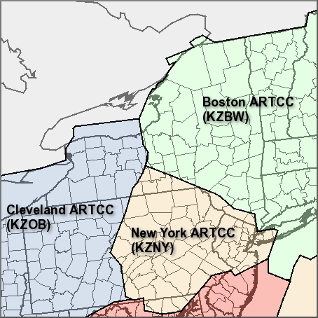
Three Center Weather Service Unit (CWSU) cover the NWS Binghamton, NY County Warning Area. Click on the map or one of the links below the map to go to the corresponding CSWU website.
Text links...
Decoded/Raw Text
| Location | Sky/Weather | Temperature | Dewpoint Temperature | Relative Humidity | Wind | Pressure | Remarks |
| Binghamton, NY | LGT RAIN | 70 | 65 | 84 | S6 | 29.92S | |
| Cortland, NY | CLOUDY | 70 | 63 | 78 | CALM | 29.90S | |
| Dansville, NY | N/A | N/A | N/A | N/A | MISG | 29.83S | |
| Elmira, NY | LGT RAIN | 69 | 66 | 90 | CALM | 29.86S | |
| Ithaca, NY | CLOUDY | 71 | 66 | 84 | SE10 | 29.88F | |
| Monticello, NY | CLOUDY | 68 | 66 | 93 | SE5 | 29.98S | |
| Penn Yan, NY | MOCLDY | 68 | 65 | 90 | CALM | 29.85S | |
| Rome, NY | MOCLDY | 73 | 64 | 73 | E8 | 29.88S | |
| Syracuse, NY | MOCLDY | 74 | 65 | 73 | SE7 | 29.85R | |
| Hazleton, PA | CLOUDY | 72 | 66 | 83 | SE3 | 29.97F | |
| Scranton, PA | CLOUDY | 72 | 67 | 84 | CALM | 29.92S | |
| 500 AM EDT SUN AUG 02 2026 | |||||||
METAR Request form via the Aviation Weather Center. Raw and decoded observations.
​Surface Weather Maps
Miscellaneous

